CGS Labs Blog

What Is BIM?
Construction is one of the fields that is constantly evolving and changing. One of the most significant developments in…
0 Comments3 Minutes

Do You Know the Difference Between Road Reconstruction and Rehabilitation?
Road maintenance and development are crucial aspects of infrastructure management, ensuring safe and efficient…
0 Comments5 Minutes

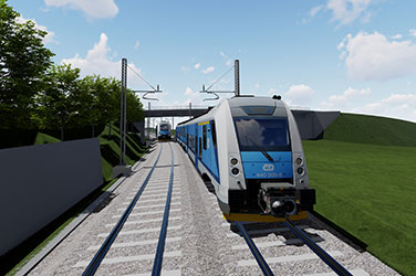
Revolution on Tracks: The Continuous Evolution of Railway Vehicles
Railways have played a pivotal role in shaping human history, revolutionizing transportation and connectivity. The…
0 Comments4 Minutes

High Capacity Vehicles: Environmental Problem or Solution?
In the ever-evolving landscape of transportation, High Capacity Vehicles (HCVs) emerge as formidable contenders for the…
0 Comments6 Minutes

Innovative Approaches to Designing Flood Protection Measures: Bright Side of Extraordinary Floods in Slovenia in 2023
In early August 2023, Slovenia was hit by a period of heavy rainfall with recurring storms, strong downpours, and…
0 Comments13 Minutes

Game-Changing Innovations:
Autopath 2024.1
We are thrilled to announce the arrival of Autopath 2024.1, a landmark release that we believe will revolutionize your…
0 Comments6 Minutes

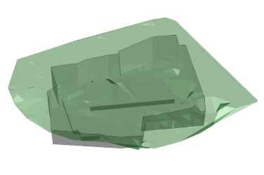
New 3D BIM modelling methods for road and rail infrastructure
Matjaž Šajn, M. Sc. Civil Eng., CEO, Leon Leban, Product Manager, Klemen Ozimek, Bs. Civil. Environ., Petra Tihole,…
0 Comments2 Minutes

The Historical Evolution of Road Markings
For centuries, roads have played an exceedingly important role in the development of human civilization, as they have…
0 Comments5 Minutes

IPSA | How CGS Labs software helped us design a rapid exit taxiway for Sarajevo International Airport
CGS Labs software is a trusted solution for many companies that want to enhance their project management and…
0 Comments7 Minutes

Projection lines labeling options in the profile view band
For several years now, CGS Labs Civil Solutions (Plateia, Ferrovia, Aquaterra) has empowered users with the capability…
0 Comments2 Minutes

AUTOPATH 2024 features a new package – Intralogistics
Looking to take your logistics and warehouse management game to the next level? You know how crucial it is to have…
0 Comments4 Minutes

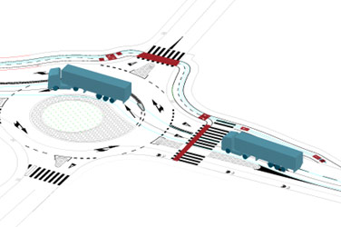
MT Projekt | The construction of a “Park & Ride” parking lot
Michał Gal is a talented and highly promising civil engineer from MT Projekt, who shared with us an innovative parking…
0 Comments8 Minutes

Three clicks are all you need: say goodbye to manually connecting points to a polyline
The Polyline from Points tool is a highly efficient software tool that enables the quick creation of specialized…
0 Comments2 Minutes
The Easiest Volume Calculation Guide You’ll Ever Need!
The Surface Volume Tool provides earthwork calculation values based on reference surfaces. This volume calculation is…
0 Comments3 Minutes

AUTOPATH 2023.1 introduces Rear Steering Vehicles
The new version of AUTOPATH 2023.1 brings some practical functionalities and improvements. It supports rear steering…
0 Comments1 Minutes

GRANOVA | First newly constructed railway line in Croatia in 52 years
Project name: New railway line Gradec – Sveti Ivan Žabno Location: Croatia Design team: Granova, a specialised project…
0 Comments9 Minutes

GRANOVA | Analysis of Podsused – Tvornica – Samobor – Perivoj railway construction options
Based on the Transport Development Strategy, the Republic of Croatia has defined general objectives through which it…
0 Comments9 Minutes

SIMM Engineering’s PLATEIA Experience
Foto: SIMM Engineering" My first experience with PLATEIA software goes back to the 90s. I worked on a project for a…
0 Comments4 Minutes

VIAING’s experience using PLATEIA software on road infrastructure projects
Company VIAING was founded in 2012 by Riste Ristovski, a civil engineer, with more than 30 years of experience in…
0 Comments5 Minutes

How to change the direction of the station?
A station control tool enables one or more station value definitions along the alignment. This tool is integrated…
0 Comments2 Minutes

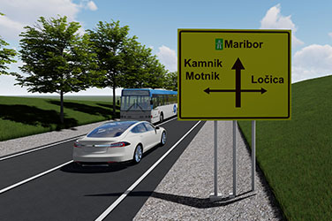
Traffic signs and directional signs with editable text
Did you know that AUTOSIGN software allows you to easily edit text and attributes of traffic or directional signs and…
0 Comments2 Minutes

External Reference Surfaces
Alignments, points, polylines and other entities supported by CGS Labs solutions can be now projected/draped to…
0 Comments10 Minutes
A new generation of Autopath software
In the latest release, our development team has proven once again, that they know how to think out of the box and they…
0 Comments5 Minutes
Was the choice of the track gauge value a coincidence?
Track gauge is the minimum distance between the inner edges of the rail heads and is measured at a distance of 0 to 14…
0 Comments4 Minutes

TCS Elements Manager
»TCS elements manager« is a tool used for zooming to a specific cross-section or elements within the cross-section…
0 Comments3 Minutes

Unusual road traffic signalling around the world
An interactive method for creating swept path analysis - Easy Drive The…
0 Comments4 Minutes

Points report
Plateia, Ferrovia and Aquaterra offers several functionalities to export points into different file formats. Points…
0 Comments3 Minutes

BIM pilot project Godovič
Can you imagine that more than a thousand experts are involved in one project and they are drawing the road on paper?…
0 Comments5 Minutes

PNZ | Construction documentation for road Hrastnik – Zidani Most and road deviation Rimske Toplice – Zidani Most – Radeče
Project name: Construction documentation G2-108 Hrastnik – Zidani Most and road deviation G1-5 Rimske Toplice…
0 Comments5 Minutes

VILNIAUS PLANAS | Reconstruction of streets and bicycle paths in Vilnius, the capital of Lithuania
Vilniaus planas has been working hand-in-hand with Vilnius City Municipality for over 20 years. We are currently…
0 Comments3 Minutes

CIP | State border railway line section Novi Sad – Subotica
Institute of Transportation CIP from Belgrade, Serbia used CGS Labs software FERROVIA to design a state border railway…
0 Comments2 Minutes
Discover 2022.2
We are delighted to welcome you back to Autosign blog. There are exciting news coming up and we would like to share it…
0 Comments5 Minutes
Welcome Autopath 2022.2
Hello, dear Autopath users. We have started the new year by developing new functionalities that are now included in the…
0 Comments2 Minutes

Automated creation and editing of cross-sections
Macro feature automates the creation and editing of cross-sections, which significantly speeds up the designing…
0 Comments4 Minutes

BIM is the key to successful railway projects
Railway infrastructure is a complex and multi-disciplinary engineering system that must be planned very carefully and…
0 Comments4 Minutes

All-in-one
Warm welcome to this post, Today’s topic is one of the most interesting aspects that must be treated when targeting a…
0 Comments5 Minutes
New version 2022.1, brings new enhancements
We are pleased to announce the launch of our new software version. Autopath 2022.1 incorporates a variety of…
0 Comments2 Minutes
AUTOSIGN 2022.1 – Straight ahead
ATTENTION: This post includes extremely valuable news. WHAT We are delighted to announce the release of the newest…
0 Comments5 Minutes

Strenk Management Consulting Uses Autopath for Expert Testimony
A recent case highlights how SMC relies on CGS Labs Autopath. SMC was hired to provide expert witness services for a…
0 Comments5 Minutes

KUKA delivers industrial flexibility with Autopath
Designing and implementing paths for automated vehicles is a challenge. They must be able to navigate the work area (in…
0 Comments8 Minutes

IFC – I feel curious
Kind welcome to this new post! No, we neither misunderstood the meaning of “IFC” nor decided to change its meaning.…
0 Comments3 Minutes

Areas of application – Autosign
Warm welcome to this new post! Probably none of you is entirely aware of all the ways on which Autosign can be useful…
0 Comments2 Minutes

Follow the signs – Autosign 2022 is out!
We are thrilled to welcome you to Autosign blog! From CGS Labs we have established this space to share information,…
0 Comments4 Minutes

Autopath 2022 is available now!
We are introducing a new software version. Autopath 2022 includes exciting new enhancements and functionality that…
0 Comments2 Minutes

Hello, Autopath 2021.1!
I am very pleased to announce that we have released Autopath 2021.1! This version brings some new features that help…
0 Comments2 Minutes

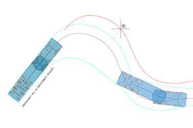
Horizontal swept path Analysis
With Autopath, swept path analysis can be made simply by clicking on a polyline, 3D polyline, or alignment defining a…
0 Comments1 Minutes

Path to win Tour de France
No words are needed! Slovenia celebrates a double victory at Toure de France! Autopath is Slovenian product…
0 Comments1 Minute

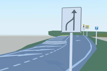
TRAFFIC CALMING – narrowing the streets
Traffic calming is a system of design and management strategies that aim to balance traffic on streets with other…
0 Comments1 Minutes

An interactive method for creating swept path analysis
With Autopath various methods are available for creating horizontal and vertical swept path analysis. Interactive,…
0 Comments2 Minutes

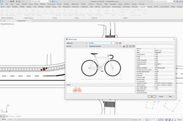
Vehicle libraries
To facilitate the swept path analysis process, Autopath already includes a list of predefined vehicle design libraries…
0 Comments4 Minutes

Why Swept Path Analysis is useful – II
Have you ever wondered how wind farms are created? No, they do not grow on site. Every component of the windmill must…
0 Comments3 Minutes

Why Swept Path Analysis is useful – I
Design software applications for a site or urban development sometimes need to prove that the plan layout can…
0 Comments2 Minutes

Hello, Autopath 2021!
I am happy to inform you that we released Autopath 2021! The release brings some new functionality and support for the…
0 Comments1 Minutes

What is Swept Path Analysis
Swept Path Analysis is the calculation and analysis of the movement and path of different parts of a vehicle when that…
0 Comments3 Minutes

Google Maps Import
Autopath provides unique raster imagery and Elevation data (Earth Surface data) insertion options and Street View…
0 Comments1 Minutes

Alm River flood risk mapping
Ingenieurbüro Neukirchen, a reputable consulting company from Vienna, Austria, has used the AQUATERRA-MIKE connection…
0 Comments1 Minutes
