


2D/3D/BIM traffic signal design planning
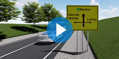
Autosign is a professional software solution for planning traffic signal design in Civil3D, AutoCAD, or BricsCAD. It generates detailed documentation, layouts, and reports. It generates detailed layouts, reports, 3D (BIM) objects, and realistic visualizations.

Libraries of traffic signs and road markings
Autosign includes extensive collections of country-specific traffic sign libraries and road markings.

Intuitive user interface
Autosign’s carefully designed user interface and workflows make it consistently user-friendly software.
Features
Autosign provides several country-specific road-signaling libraries defined by national guidelines, including traffic signs, longitudinal road markings, crossing road markings, and various other pavement markings.
Users also have an advanced option to create a custom library of their own traffic signs blocks and use them in the designs with the same features that are available with the original Autosign signs.
Available localized libraries of country-specific traffic signs and road marking with 3D/BIM support:
| USA | American Manual on Uniform Traffic Control Devices (MUTCD) and its companion volume the Standard Highway Signs (SHS) |
| AUSTRALIA | Australian Manual on Uniform Traffic Control Devices (MUTCD) |
| AUSTRIA | Austrian legislation (Bundesgesetz vom 6. Juli 1960, mit dem Vorschriften über die Straßenpolizei erlassen werden (Straßenverkehrsordnung 1960 – StVO. 1960)) |
| BOSNIA AND HERZEGOVINA | Bosnian legislation (Pravilnik o saobraćajnim znakovima i signalizaciji na cestama, načinu obilježavanja radova in prepreka na cesti in znakovima koje učesnicima v saobraćaju daje ovlašćena osoba, 2017) |
| BULGARIA | Bulgarian legislation (Road traffic signs. Dimensions and letters. Bulgarian Standard BDS 1517) |
| CROATIA | Croatian legislation (Pravilnik o prometnim znakovima signalizaciji in opremi na cestama NN 92-19, 2019) |
| CZECH REPUBLIC | Czech legislation (Vyhláška, kterou se provádějí pravidla provozu na pozemních komunikacích, 2015) |
| CZECH RAIL | Library of rail signals. |
| ESTONIA | Estonian legislation (EVS613:2001, EVS614:2008) |
| GERMANY | German legislation (Verkehrszeichenkatalog, 2017. Letzte Aktualisierung 06/2024) |
| LATVIA | Latvian legislation (Ceļu satiksmes noteikumi, 2015) |
| LITHUANIA | Lithuanian legislation (Kelio ženklų įrengimo in vertikaliojo ženklinimo taisykles. Žin., 2008, Nr. 46-1730. 2012.) |
| NEW ZEALAND | New Zealand legislation (Traffic Control Devices Manual) |
| ROMANIA | Romanian legislation (Standard Român ASRO. SR 1848 – 1, 2024 & SR 1848 7 2015) |
| POLAND | Polish legislation (Rozporządzenie w sprawie znaków i sygnałów drogowych (Dz.U. z 2019 r. poz. 2310)) |
| QATAR | Library of traffic signs based on the Qatar Traffic Control Manual (QTCM) |
| SERBIA | Serbian legislation (Pravilnik o saobracajnoj signalizaciji, 2017) |
| SLOVENIA | Slovenian legislation (Pravilnik o prometni signalizaciji in prometni opremi na cestah, 2024) |
| SWEDEN | Swedish legislation (Transportstyrelsens Författningssamling | TSFS 2019:74 | TSFS 2010:171 | TSFS 2014:30) |
| SLOVENIA – VARNEJE V SOLO | Varneje v šolo (Smernice za postavitev in izvedbo urbane opreme ter arhitekturnega oblikovanja prometnih površin za izboljšanje prometne varnosti otrok – šolarjev) |
When you are working on road design projects in either Civil 3D, AutoCAD or BricsCAD, Autosign can be used to draw and plan a complete road signalization and prepare the necessary documentation.
You can link Autosign signaling elements (traffic signs and road markings) to the information of your Civil 3D alignment, or any other Polyline alignment in your drawing.


Parking lot design tool enables a parametric design of parking lots. To speed up the design process, Autosign provides a wide variety of floor markings that can be assigned to the design: single lines, double lines, dashed lines, coloring, and many more. Users can either take advantage of the predefined markings that are specific to individual countries* or they can choose to define markings with custom parameters that can be saved for repeated use.
All floor markings created with Autosign can be projected on the road surface or any other surface of the DTM, creating 3D floor markings, with assigned BIM properties.
The parking lot design report is another handy feature that will provide you with a detailed table of quantities which can be either included directly in the design or exported to XLS format for further use.

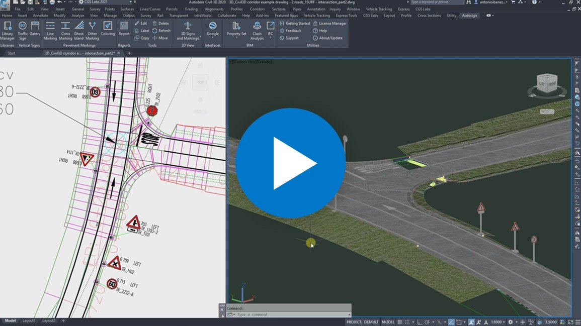


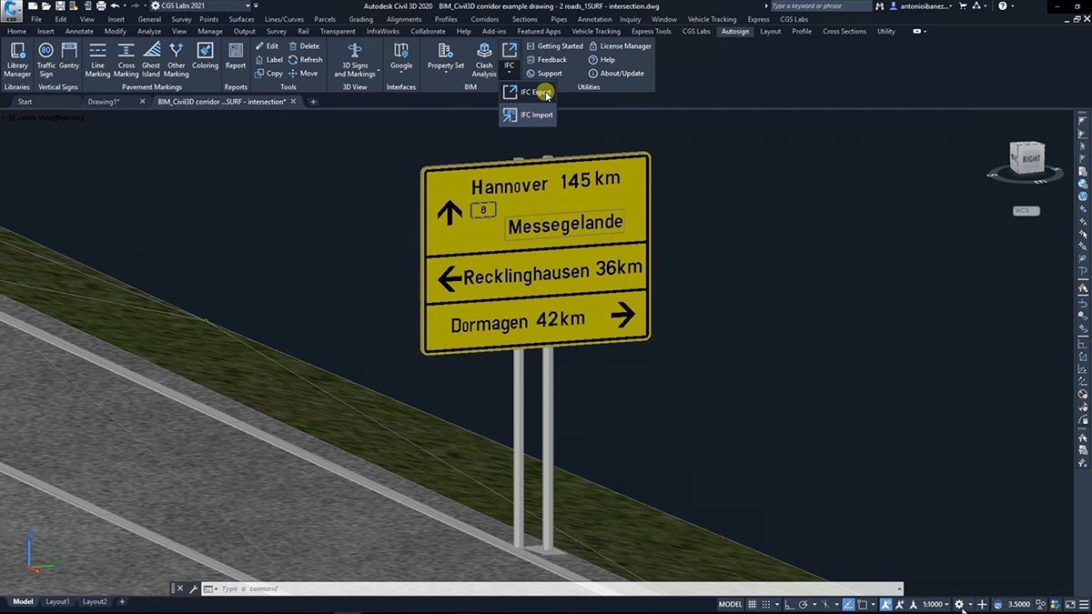
Autosign creates traffic signs, portals, road markings, and other side road objects as BIM objects (3D solid objects with assigned Property Set data), that can be viewed and manipulated in Autodesk Navisworks and InfraWorks or exchanged through the IFC 4.2 file format to be used in any BIM-ready software solution.


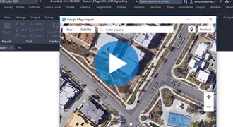
Autosign provides the option to import earth surface data (raster imagery and elevation data) from Google Maps directly into your CAD drawing to help visualize areas where the projects are located.
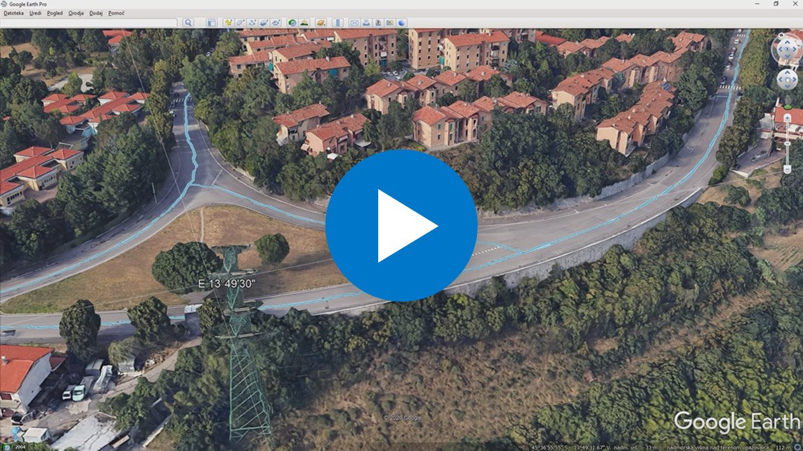
You can also export your 3D designs directly to Google Earth. In this way, you can create accurate visualizations on the exact location of the project.
Fields of use
Infrastructure design
- Roadways
- Pedestrian areas
- Bicycle networks
- Urban areas


Traffic management
Use Autosign for planning traffic signs and road markings in both urban and inter-urban road infrastructure, redesigning the traffic flow or implementing new practical solutions to any problem that traffic engineers may face.
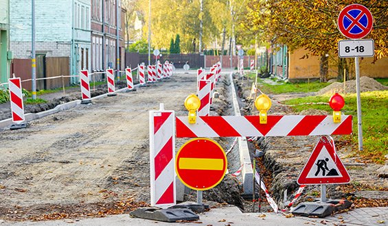
Road works and Temporary Situations
Indicate lane closures and road works, create diversion paths, set safety and visible limits for pedestrian sidewalks and manage the signaling of every temporary situation that occurs in your project.

Car parking areas
Autosign provides tools to design details of parking facilities, such as delimitation lines, vertical signaling, height control gantries, and more.
Warehouse traffic design and management
Design signaling for indoor and outdoor traffic, warning and restricted areas for warehouses, production facilities, and industrial areas.

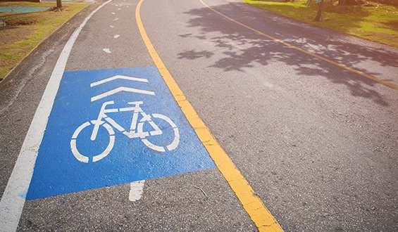
Cycle path network design
Urban planners will be able to shape every pavement marking and vertical sign to design sustainable cycle path networks, as well as to paint the paths or other elements.
Ski resort & Sport centre design
Facilities designers will discover in Autosign a product to design the requested signaling for ski slopes, as well as floor markings for courts and pitches of any sport – even running tracks.


Motor-racing circuits & Safety driving centre design
Design the signaling and equipment at the highest level in term of competition and safety.
Fields of use
Infrastructure design
- Roadways
- Pedestrian areas
- Bicycle networks
- Urban areas
Traffic management
Use Autosign for planning traffic signs and road markings in both urban and inter-urban road infrastructure, redesigning the traffic flow or implementing new practical solutions to any problem that traffic engineers may face.
Road works and Temporary Situations
Indicate lane closures and road works, create diversion paths, set safety and visible limits for pedestrian sidewalks and manage the signaling of every temporary situation that occurs in your project.
Car parking areas
Autosign provides tools to design details of parking facilities, such as delimitation lines, vertical signaling, height control gantries, and more.
Warehouse traffic design and management
Design signaling for indoor and outdoor traffic, warning and restricted areas for warehouses, production facilities, and industrial areas.
Cycle path network design
Urban planners will be able to shape every pavement marking and vertical sign to design sustainable cycle path networks, as well as to paint the paths or other elements.
Ski resort & Sport centre design
Facilities designers will discover in Autosign a product to design the requested signaling for ski slopes, as well as floor markings for courts and pitches of any sport – even running tracks.
Motor-racing circuits & Safety driving centre design
Design the signaling and equipment at the highest level in term of competition and safety.
Supported languages
- Austrian German
- Croatian
- Czech
- English
- German
- Hungarian
- Polish
- Serbian
- Slovenian
Supported CAD platforms
- Autodesk® AutoCAD® 2018 - 2027 (except AutoCAD LT)
- Autodesk® Civil 3D® 2018 - 2027
- BricsCAD® Pro, BIM and Ultimate V22 – V26
* Only 64-bit versions are supported
Functionalities
Available as a standalone or network license
- Access to national libraries of traffic signs and road markings
- Traffic signs design
- Custom traffic signs
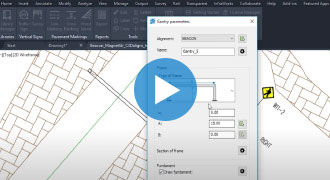
- Gantry design
- Pavement markings design (line markings, cross markings, ghost islands, arrows, etc.)
- Coloring of pavement areas
- Reports of traffic signs and road markings (with quantities)
- Import of earth surface data from Google Maps
- 3D traffic signs and road markings
- Export 3D designs to Google Earth
- Support for 3D Solid objects (compatible with InfraWorks and Navisworks)
- BIM tools (Property set Manager / Editor / Filter)
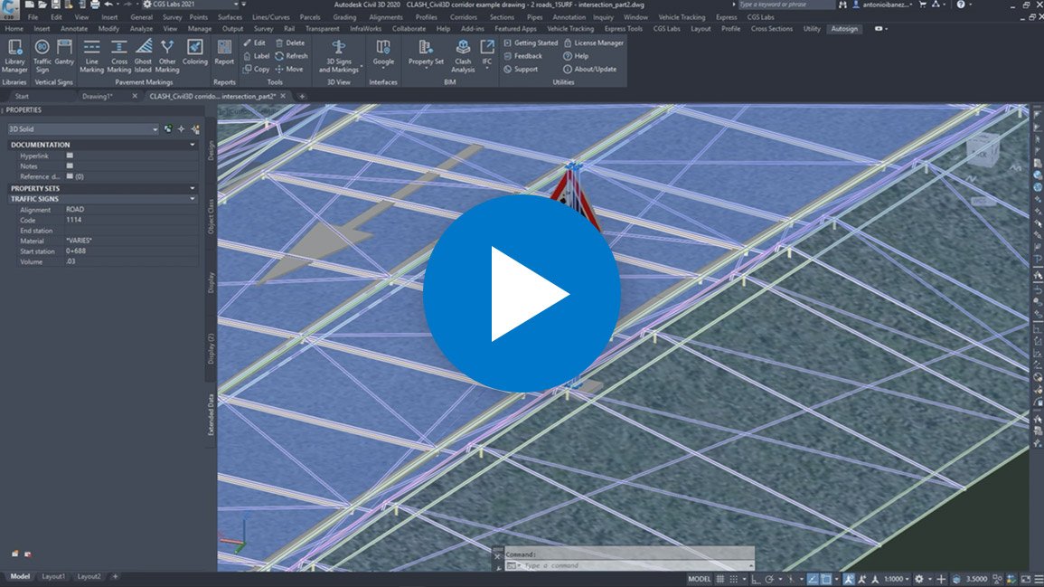
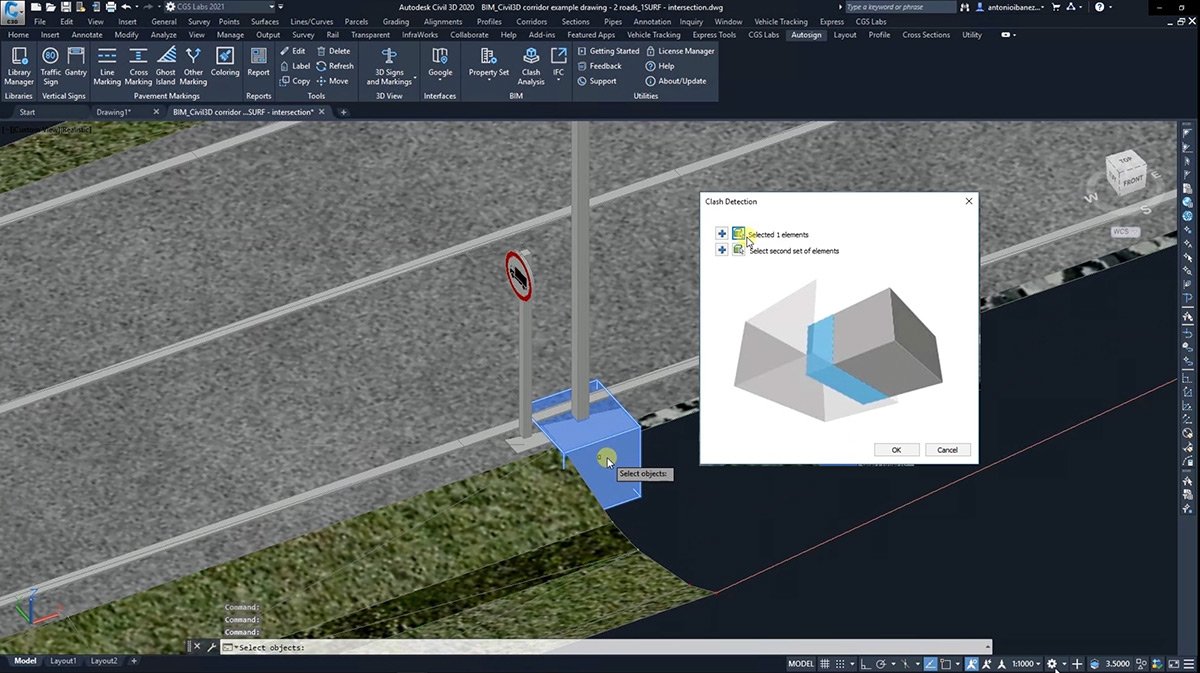
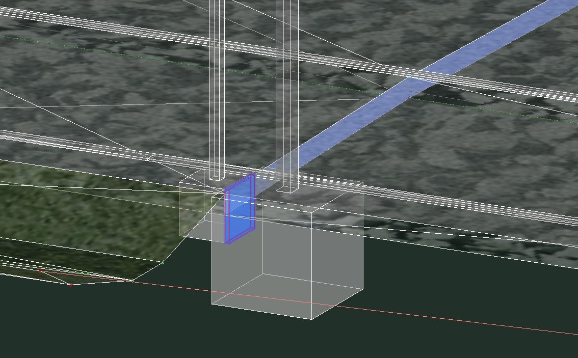
- Clash Analysis within AutoCAD, Civil 3D, and BricsCAD
- Import & Export to IFC 4.2 file format for data exchange with other BIM software
- Access to national libraries of traffic signs and road markings
- Traffic signs design
- Custom traffic signs
- Gantry design
- Pavement markings design (line markings, cross markings, ghost islands, arrows, etc.)
- Coloring of pavement areas
- Reports of traffic signs and road markings (with quantities)
- Import of earth surface data from Google Maps
- 3D traffic signs and road markings
- Export 3D designs to Google Earth
- Support for 3D Solid objects (compatible with InfraWorks and Navisworks)
- BIM tools (Property set Manager / Editor / Filter)
- Clash Analysis within AutoCAD, Civil 3D, and BricsCAD
- Import & Export to IFC 4.2 file format for data exchange with other BIM software


