


BIM Channel/River engineering design
Aquaterra is a professional software for channel and river engineering design. It integrates MIKE 11 and HEC-RAS hydraulic calculations with flood protection design, torrent and landslide control, and irrigation systems design. Using its flexible, dynamic data model, it supports BIM workflows and processes, and IFC standardized data format.

Intuitive user interface
Carefully designed UI and workflows are consistent with the engineering practices. This makes Aquaterra surprisingly fast-to-learn and easy-to-use.

From preliminary to detailed design
Aquaterra facilitates design in all stages of the project, from conceptual studies to detailed design. From the river axis, longitudinal and cross-sections data, user can quickly build a 3D Solid model of river bed and river bank, calculate quantities, and prepare printed documentation.
Features
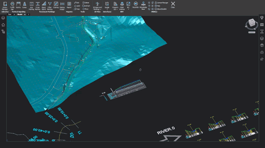
 CGS Labs solutions provide extensive BIM data support not limited to CAD platforms in use. 3D roadway, railway or river channel models are generated as detailed 3D solid objects with extended BIM metadata attached to objects, or as multiple surfaces for use with computer guided machines etc..
Aquaterra offers capable Property Manager for adding and changing 3D solids property data, which enables COBie (Construction Operations Building Information Exchange) compatibility.
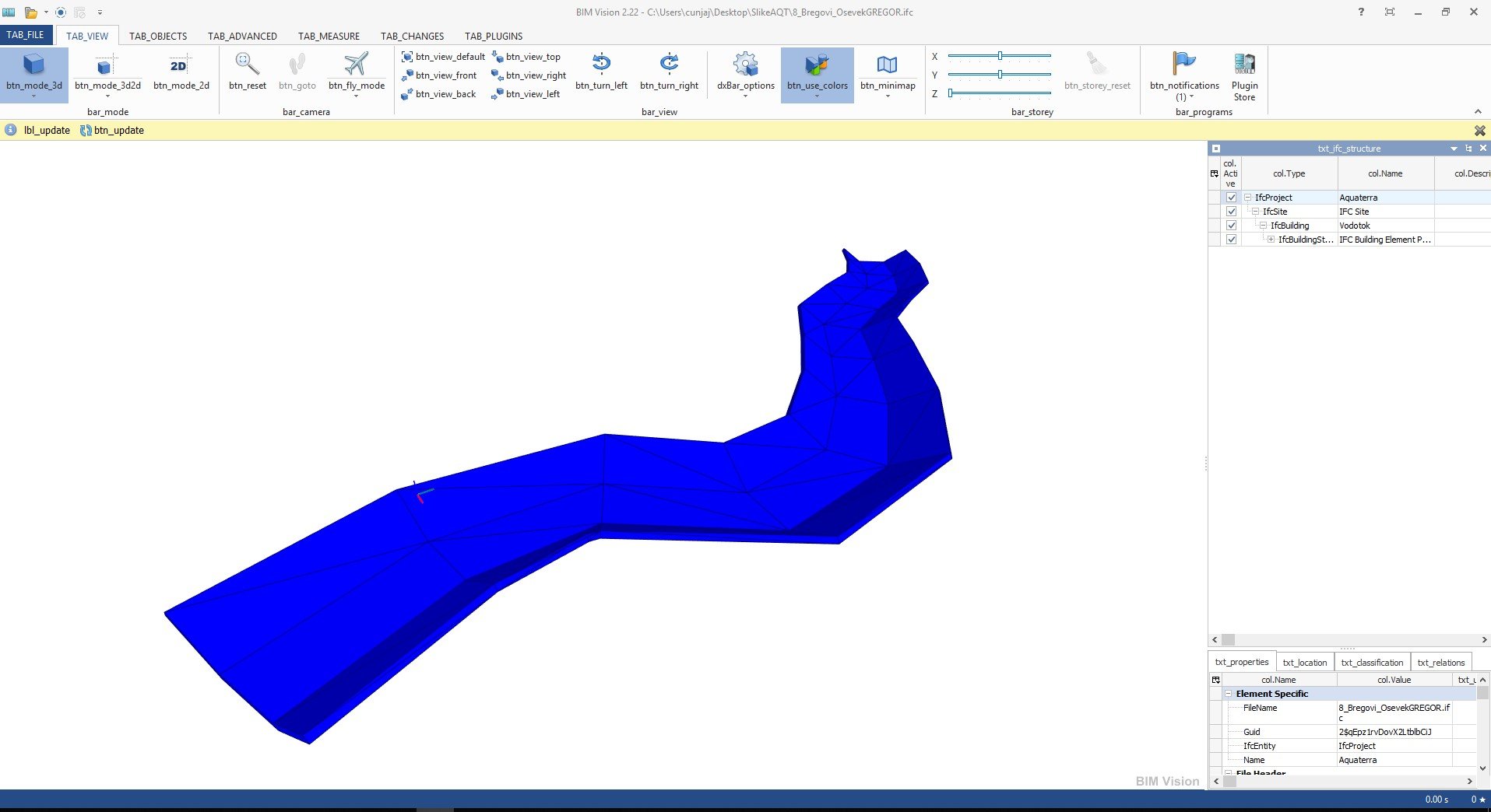
Aquaterra 3D models and attribute data can be exported to IFC files. IFC export format is regularly updated according to buildingSMART International specifications.
Clash detection tool enables designer to search for possible collisions among selected 3D solid objects within the drawing itself thus saving the time to export models and create clash analysis in third party applications outside CAD environment.


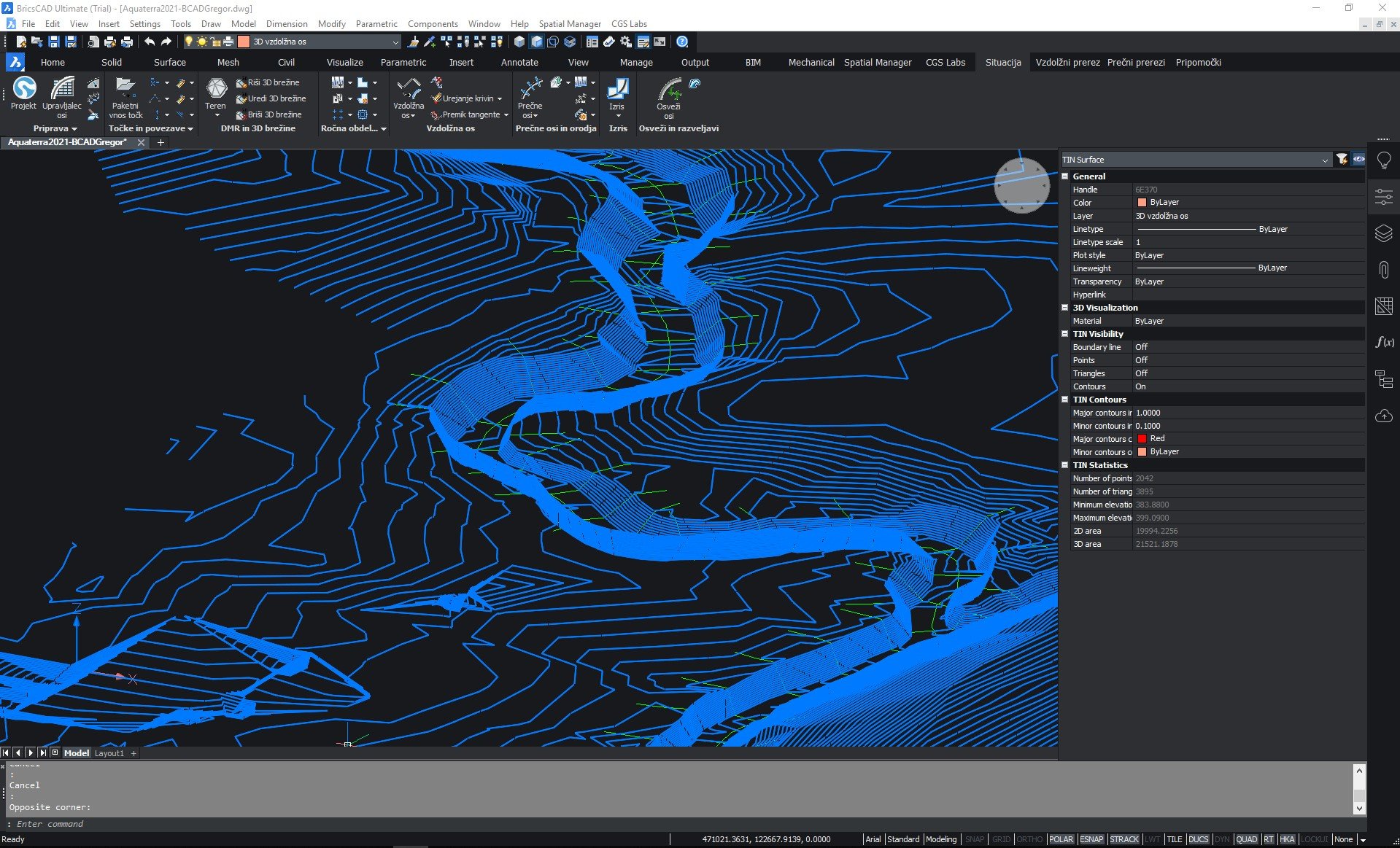
Digital Terrain Modeling
The Surface creation tool is included in CGS Labs software to produce a detailed Digital Terrain Model (DTM) based on various surveys or other input data: total station data files, points, break lines, blocks, etc. This offers the possibility to use Aquaterra on plain AutoCAD or BricsCAD. Aquaterra supports also surfaces from Civil 3D and BricsCAD (V20 or newer).

Grading
Creation of complex slopes with multiple conditions in cut or fill gives users the capability to cover various design scenarios and geometry requirements for all kind of road projects, from simple forest road design to complex intersection geometry design. Furthermore, creating ponds, parking areas, platforms, road, rail tracks, river channels, and other features is easier and faster with CGS Labs grading functionality.
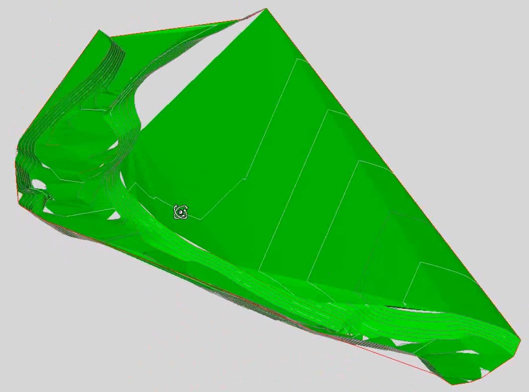
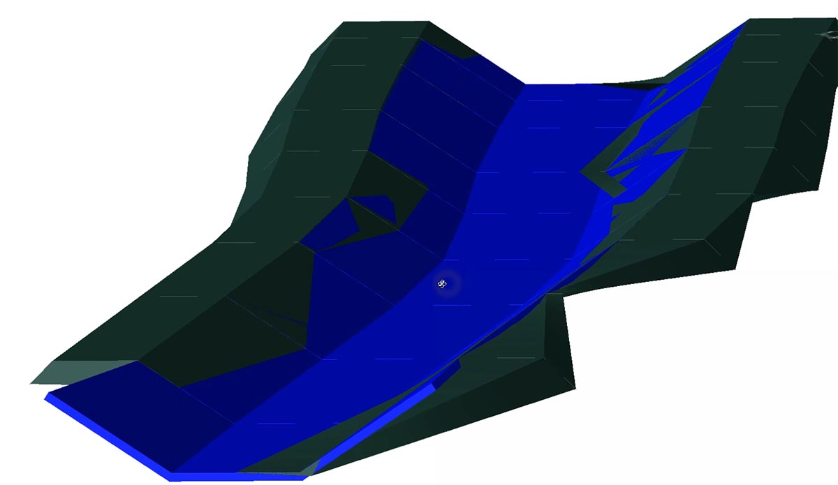
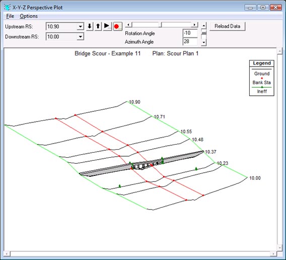
3D Surface and 3D Solid Model
Channel and river bed 3D model can be created as 3D surface or 3D solid model. 3D surface model can be generated automatically from 3D channel or river bed cross sections definition and terrain model, or it can be built with the grading function. 3D solid model is created on the basis of cross-section areas, with materials and volumes defined as extended data. All solid models, including extended data, can be imported into Autodesk Infraworks, Navisworks and can be used in various BIM workflows.
River alignment design tools
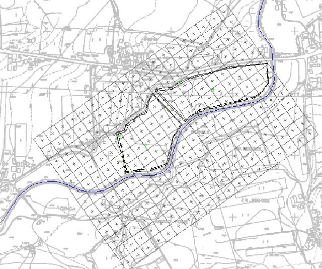
Aquaterra provides a wide range of advanced alignment, profile geometry design, and editing tools. They include P(V)I design, floating and fixed elements design, alignment design created from the existing polyline, or ultimately creating a best-fit alignment based on existing channel or river bed survey data. A number of alignment labels, reports and data export options give you the flexibility to cover a wide range of user requirements.

Water level representation and smart lines definition
Water level lines represent data obtained from hydraulic calculation software (MIKE 11 or HEC-RAS). They are displayed relative to the specific alignment in the drawing. To present side objects like channels, dykes, property limits, etc., you can define smart lines in the layout and project them to profile and/or cross section views. The Smart lines functionality is connected with the point’s projection, which offers similar projection options, but dedicated to point objects along any alignment.

Cross sections design and editing capabilities
Enter 1D, 2D water levels or combined calculations and design new or edit existing channel and river bed cross sections geometry. Add dykes and other objects using the large set of tools available. Recalculate water levels and check geometry changes impact for accurate project evaluation.
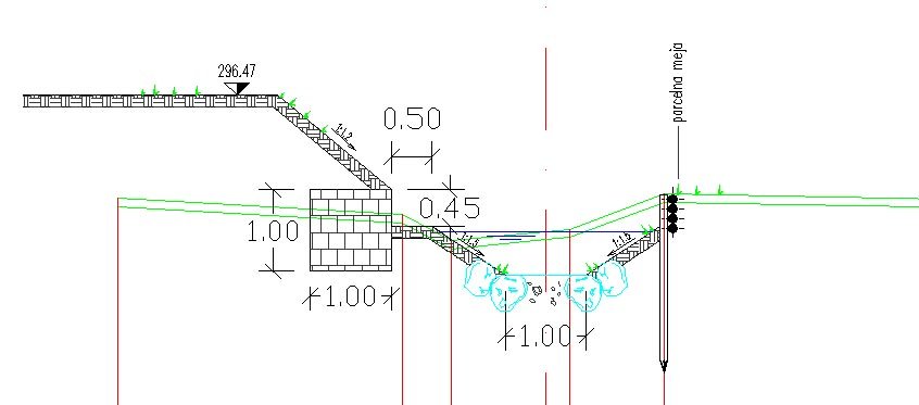

River groins
Groins are a rigid hydraulic structures built from a bank in rivers that interrupt water flow and limit the movement of sediment. Aquaterra supports design of groins along selected banks as 2D elements with varying gradient values.

Quantity take-off (QTO)
Aquaterra calculates material quantity take-off and features a QTO data export tool with custom defined Pay Item (Bill of materials) options. It gives users the possibility to link material defined in the drawing with a material database in cost estimate software, thus supporting digital data transfer and fast cost recalculation when project changes arise.

Mass Haul Diagram
Mass haul diagram presents a graphical view of the material moved in the proposed design site. Mass haul diagrams help designers and contractors understand where gross material movements occur and compare the economies of alternative designs.
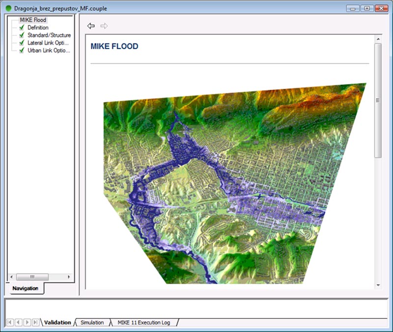
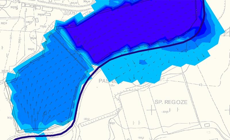
MIKE 11 by DHI is an advanced professional flood modeling solution that enables simulation of any flood problem. It can involve rivers, floodplains, flooding in streets, drainage networks, coastal areas, dams, levee and dike breaches, or any combination of these.
Aquaterra’s integrated MIKE 11 interface transfers graphical data into MIKE 11 where water flow calculations are made. These results are transferred back into Aquaterra where water levels can be displayed in profile and cross section.
MIKE 11 2D results (floodplain lines) export to Aquaterra is also supported for drawing production within the CAD environment.
HEC-RAS is an established software for one-dimensional steady flow and two-dimensional unsteady flow hydraulic calculations.
Aquaterra’s integrated HEC-RAS interface enables the transfer of channel or river geometry from a CAD environment into HEC-RAS where water flow calculations are made. Calculation results can be transferred back into Aquaterra where calculated water levels are displayed in profile and cross sections. Taking into account the results, engineers can now modify existing channel or river topography, using Aquaterra’s advanced cross-section design and editing tools.
Through Aquaterra’s interface, geometry can also be imported directly from HEC-RAS, edited in Aquaterra and sent back to HEC-RAS for further analysis.

Google Maps & Google Street View
Google Maps Import makes it easy to import raster images and elevation data of a selected location from Google Maps into a DWG drawing in the selected coordinate system. Google Street View functionality is also available to allow the user to view the selected area interactively within the CAD environment.
Google Earth Export
BIM (3D solid) model of the infrastructure can be quickly visualized directly into Google Earth. This allows us to present the project in an environment that enables the user to have exceptional visual performances.
Supported languages
- English
- German
- Croatian
- Serbian
- Slovenian
Supported CAD platforms
- Autodesk® AutoCAD® 2018 - 2027 (except AutoCAD LT)
- Autodesk® Civil 3D® 2018 - 2027
- BricsCAD® Pro, BIM and Ultimate V22 – V26
* Only 64-bit versions are supported
Select the version according to your needs
Available as a standalone or network license
- Survey data import
- Digital terrain modeling tool (CGS Labs DTM)
- 3D Grading
- Support for Civil 3D in BricsCAD surface
- Alignment design
- Profile design
- Cross sections design
- 3D River modeling
- Points, lines and 3D solids projection to Profile View & Cross Sections Views
- Labeling and dimensioning tools
- Quantity Take-off & Mass Haul diagrams
- Riverbanks design
- River groins design
- Water level representation
- Interface for Civil 3D objects <-> Aquaterra
- Support for HEC-RAS hydraulic interface
- Support for MIKE 11 by DHI hydraulic interface
- Support for 3D Solid objects
- BIM object property tools (manager/editor/filter)
- 3D/BIM object clash analysis within AutoCAD, Civil 3D, and BricsCAD
- Import of Google Maps geospatial data in CAD drawing
- Import/Export LandXML data
- Import/Export 3D/BIM model to IFC 4.2 data format
- Export 3D river model to Google Earth
- Survey data import
- Digital terrain modeling tool (CGS Labs DTM)
- 3D Grading
- Support for Civil 3D in BricsCAD surface
- Alignment design
- Profile design
- Cross sections design
- 3D River modeling
- Points, lines and 3D solids projection to Profile View & Cross Sections Views
- Labeling and dimensioning tools
- Quantity Take-off & Mass Haul diagrams
- Riverbanks design
- River groins design
- Water level representation
- Interface for Civil 3D objects <-> Aquaterra
- Support for HEC-RAS hydraulic interface
- Support for MIKE-FLOOD by DHI hydraulic interface
- Support for 3D Solid objects
- BIM object property tools (manager/editor/filter)
- 3D/BIM object clash analysis within AutoCAD, Civil 3D, and BricsCAD
- Import of Google Maps geospatial data in CAD drawing
- Import/Export LandXML data
- Import/Export 3D/BIM model to IFC 4.2 data format
- Export 3D river model to Google Earth


Our Customers’ Journey


