


BIM Roadway Design
PLATEIA is a 3D road design and road reconstruction design software that supports BIM workflows and processes.

Intuitive user interface
Carefully designed UI and workflows are consistent with the road design engineering practice, which makes PLATEIA very easy-to-use.

For all design stages
PLATEIA's tools support the entire design process. From the input of survey data to the design of complex 3D road models and documentation.
Our Customers’ Journey


Key features of PLATEIA
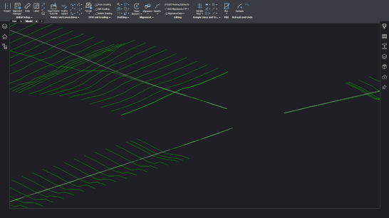
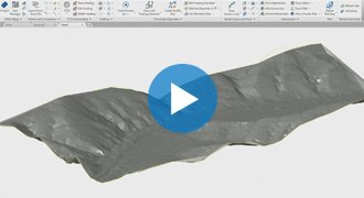
Digital terrain modeling
The Surface creation tool is included in CGS Labs software to produce a detailed Digital Terrain Model (DTM) based on various surveys or other input data: total station data files, points, break lines, blocks, etc. This offers the possibility to use Plateia on plain AutoCAD or BricsCAD. Plateia supports also surfaces from Civil 3D and BricsCAD (V20 or newer).

Grading
Creation of complex slopes with multiple conditions in cut or fill gives users the capability to cover various design scenarios and geometry requirements for all kind of road projects, from simple forest road design to complex intersection geometry design. Furthermore, creating ponds, parking areas, platforms, road, rail tracks, river channels, and other features is easier and faster with CGS Labs grading functionality.
SITE DESIGN includes quick site modeling features, earthwork calculation, utility design, and productivity tools to speed up project delivery. It is ideal for fast conceptual projects, solution testing projects, detailed design, and earthwork projects including volume calculation, grading, and more. Serving data for machine control guidance, blueprints project delivery, survey data, and for great visualizations.

Surface
The terrain design is the main benefit of the new collection. Surface can be created based on the survey data or simply imported from Google Maps. The biggest advantage of this surface tool is that it creates ultralight surface models in an instant.
Google Maps & Google Street View
Google Maps Import makes it easy to import raster images and elevation data of a selected location from Google Maps into a DWG drawing in the selected coordinate system. Google Street View functionality is also available to allow the user to view the selected area interactively within the CAD environment.

Google Earth Export
Plateia BIM (3D solid) road infrastructure model can be quickly visualized directly into Google Earth. This allows us to present the project in an environment that enables the user to have exceptional visual performances.

Powerful geometry design tools
Plateia provides a wide range of advanced alignment, profile geometry design, and editing tools. They include P(V)I design, floating and fixed elements design and alignment design created from the existing entities.
Ultimately creating a best-fit alignment based on existing road centerline or road edge survey data. Superelevation calculation features a comprehensive definition and editing tool.
Plateia supports several superelevations definitions and pivot point options according to various European and AASHTO roadway design standards. A number of alignment labels according to different country standards, reports, and data export options offer the flexibility to cover a wide range of user requirements.
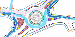
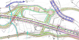
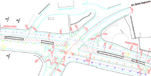
Intersections and roundabouts
Automated intersection and roundabout design based on road geometry defined by alignment, profile and super-elevations.
The 3D Intersections function automatically adjusts secondary road profile and super elevation parameters with corresponding user defined curb returns.
Automated intersection design results in detailed 3D intersection geometry for X or T shaped intersection types. Use the grading/surface mode with various parameters to customize 3D intersection geometry.


3D surface and 3D solid model
Roadway 3D models in Plateia are generated as 3D surfaces or 3D solid models. 3D roadway surface model is built automatically from 3D road edges and terrain model, or it can be built with the grading function. 3D solid model is created based on cross-section areas, where materials and volumes can be defined as extended data.
With 3D solids, we can also build tunnels, bridges and similar objects. Solid objects can be aligned with arcs and transition curves. All solid models, including extended data, can be imported into Autodesk Infraworks, Navisworks and can be used in various BIM workflows.
Detailed cross section design and editing
Plateia provides capabilities for designing and editing roadway cross sections in a detailed way with almost no geometry limitations to the final project design. Adding multiple roadways to a single cross section gives you control over the geometry between the roads and other infrastructure objects your project requires, and lets you define these areas with great accuracy and detail.


Quantity take-off (QTO)
Plateia calculates material quantity take-off and features a QTO data export tool with custom defined Pay Item (Bill of materials) options. It gives users the possibility to link material defined in the drawing with a material database in cost estimate software, thus supporting digital data transfer and fast cost recalculation when project changes arise.

Visibility and stop sight distance
The Visibility and Stop sight distance road geometry tool provides graphical visibility distance analysis required to safely stop a vehicle traveling at design speed. This facilitates planning to avoid collisions with any other immobile objects obstructing the driving path.
The road reconstruction / rehabilitation function offers powerful regression analysis tools for best-fit alignment and profile creation based on existing road centerline or road edge surveyed data.
Existing road superelevation comparison with new superelevation calculation and editing enhancements provide designers the needed tools to tackle demanding geometrical restrictions.
Integrated road reconstruction & rehabilitation tools for calculation of material removal and / or resurfacing material quantities result in new 3D road geometry data linked with QTO information.
| AUSTRIA | Österreichischen Richtlinien für Linienführung von Straßen RVS 3.23. |
| BOSNIA and HERZEGOVINA | Smjernice za projektovaje, građenje, održavanje i nadzor na putevima, 2005. |
| CROATIA | Pravilnik o osnovnim uvjetima kojima javne ceste izvan naselja i njihovi elementi moraju udovoljavati sa stajališta sigurnosti prometa (NN br. 110/01) |
| CZECH REPUBLIC | Projektování silnic a dálnic, ČSN 73 6101 |
| GERMANY | Richtlinien für die Anlage von Landstraßen, RAL 2012, RAA-2008, RASt-06 |
| POLAND | Warunków technicznych, jakim powinny odpowiadać drogi publiczne i ich usytuowanie, DU 43/1999 Rizp. 430 |
| SERBIA | Pravilnik o uslovima koje sa aspekta bezbednosti saobraćaja moraju da ispunjavaju putni oobjekti i drugi elementi javnog puta, Službeni glasnik RS, br 50/2011; JUS (UL SFRJ 35/939, 26.06.1981 |
| SLOVENIA | Pravilnik o projektiranju cest, UL RS 91/9303, 14.10.2005 |
| HUNGARY | Partially implemented. |
| For information about other country-specific standards please contact us! | |
Autosign is a professional software solution for planning traffic signal design in CAD environments. It generates detailed layouts and reports. Autosign includes extensive collections of country-specific traffic sign libraries and road markings.
*Autosign is available in Plateia Ultimate and Professional version.


Autopath is a professional software for swept path analysis and vehicle turning simulations. With it, you can easily and quickly simulate vehicle maneuvers and check transportability of all types of road design projects: on roads, intersections, roundabouts, hairpin turns, underpasses, overpasses … [read more about Autopath]

*Autopath is available in Plateia Ultimate version.

 CGS Labs solutions provide extensive BIM data support not limited to CAD platforms in use. 3D roadway, railway or river channel models are generated as detailed 3D solid objects with extended BIM metadata attached to objects, or as multiple surfaces for use with computer guided machines etc.
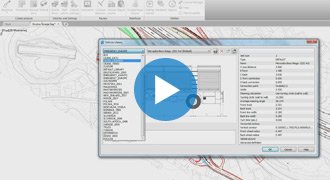
Plateia offers capable Property Manager for adding and changing 3D solids property data, which enables COBie (Construction Operations Building Information Exchange) compatibility.
Plateia 3D models and attribute data can be exported to IFC files. IFC export format is regularly updated according to buildingSMART International specifications.
Clash detection tool enables designer to search for possible collisions among selected 3D solid objects within the drawing itself thus saving the time to export models and create clash analysis in third party applications outside CAD environment.

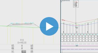
Watch webinars for PLATEIA software


Supported languages
- Austrian German
- Croatian
- Czech
- English (International)
- English (USA-AASHTO)
- German
- Hungarian
- Polish
- Serbian
- Slovenian
Supported CAD platforms
- Autodesk® AutoCAD® 2018 - 2027 (except AutoCAD LT)
- Autodesk® Civil 3D® 2018 - 2027
- BricsCAD® Pro, BIM and Ultimate V22 – V26
* Only 64-bit versions are supported
Select the version according to your needs
Available as a standalone or network license
- Survey data import
- Digital terrain modeling tool (CGS Labs DTM)
- 3D Grading
- Support for Civil 3D and BricsCAD surface
- Alignment design
- Profile design
- Cross-sections design
- Road super elevations
- 3D Road modeling
- Points, lines and 3D solids projection to Profile View & Cross Sections Views
- Labeling and dimensioning tools
- Visibility analysis & Stop sight distance
- Quantity Take-off & Mass Haul diagrams
- Intersections design 2D/3D
- Roundabout design
- Intersections islands design
- Curb return fillets
- Interface for Civil 3D objects <-> Plateia
- Regression alignment and profile design (Best-Fit)
- Regression alignment and profile analysis and editing
- Side road objects distance calculation (Off-Set calculation)
- Import of Google Maps geospatial data in CAD drawing
- 2D Traffic signs and road markings design (Autosign Professional)
- 3D/BIM Traffic signs and road markings design & visualization (Autosign Ultimate)
- 2D/3D Vehicle swept path analysis and turning simulation (Autopath Ultimate)
- Support for 3D Solid objects
- BIM object property tools (manager/editor/filter)
- 3D/BIM object clash analysis within AutoCAD, Civil 3D, and BricsCAD
- Import/Export LandXML data
- Import/Export 3D/BIM model to IFC 4.2 data format
- Export 3D road model to Google Earth


